Friday, August 2, 2013

Pilot Mountain State Park

Pilot Mountain

Lately, I have been fantasizing about the Appalachian Trail (a hiking trail that stretches over 2,150 miles (3,400 km) through the mountains from Georgia to Maine. I have been trying to convince my co-worker that she should join me for this excursion; however, she's never even gone hiking before! Since I've been talking endlessly about the Appalachian Trail, we decided to head towards the mountains of western North Carolina and try a quick day-hike (just to give her an idea of what hiking is really like.)

Although we had originally hoped to walk part of the true Appalachian Trail, we thought a 4-5 hour drive each way would be a bit much for a single day-hike. Instead, we opted for the much closer Pilot Mountain, which was only 2.5 hours north near the city of Winston-Salem.

View over the Cliffs of Pilot Mountain

Our hike on Pilot Mountain was a 7 miles (11 km) loop that took us both around and atop the mountain. I first learned of this loop hike in the book 50 Hikes in the Mountains of North Carolina, which described this trail as strenuous (in fact, it listed the required hiking time as 6.5 hours - something that scared me considering the trail was only 7 miles!) Fortunately, the trail proved much easier than I was led to believe (and took nowhere near 6.5 hours.)

Cliffs along the Ledge Spring Trail

The loop began with 3 miles (5km) of Grindstone Trail, which circled around the north side of the mountain. Although the majority of this trail was an incline, it was actually a fairly mild slope that presented no real challenge. Unfortunately, the Grindstone Trail soon joined the Ledge Spring Trail, and the real climbing began!

Although the Ledge Spring Trail was a steep climb upwards, most of it was made (slightly) easier by the endless series of stairs leading towards the mountaintop. When you are about 3/4 of the way up this trail, the tree-line starts to open up to give magnificent views of the surrounding countryside. (You also encounter endless numbers of rock climbers scaling the mountains jagged cliffs.)

When you arrive at the "top" of the mountain (you can't actually climb to the very top - you have to settle for a nearby plateau instead), you are greeted by dozens of park visitors. Pilot Mountain State Park maintains a road leading up the mountain, so that people can easily reach the scenic lookout points without all the work we went through actually climbing the mountain! Although it was a little disappointing having to share the mountaintop with so many "tourist", the functioning bathrooms and water fountains made up for the small crowd.

Mountain Trail as it Passes through Shaded Forest

From the upper parking area, we were able to enjoy great views from the park's outlook areas before continuing along the mile-long Jomeokee Trail (which circles the mountain's actual peak. Then, the trail continued down a different segment of the Ledge Spring Trail (which would have been just as challenging had we been going up.) At the base of the mountain, we followed two unremarkable trails (Mountain Trail and Grassy Ridge Trail) through the forest south of the mountain. The only challenge from this final segment was the difficulty I had in locating the dark red trail markers against the trees; for someone who is mildly colorblind, it was nearly impossible to find the route markers (thank goodness I had my coworker there to be the eyes for both of us!)

Friday, June 14, 2013

Raeford Parachute Center

This afternoon, a coworker and I traveled to Raeford, a small town located just outside of Fayetteville. We have been discussing (and compiling) our bucket lists, and decided that it was time to cross skydiving from our lists. We had made reservations to jump with the Raeford Parachute Center, which was a small airport that seems devoted primarily to parachuting.

After a brief video (which was little more than a warning that we could get hurt - and that the parachuting center would not be held responsible), we were outfitted in a jumpsuit and harness. Before we knew it, we were loading into a very small plane. The plane merely had two benches along the sides, which we had to straddle with a person directly behind us (and a person in front of us who was practically sitting on our laps - it was a very tight fit!)

Me jumping from the plane

When we reached 13,500 feet (4,115 meters), it was time to jump. Before we jumped, my jump partner asked if I wanted to jump straight out - or if I wanted to do a back-flip out of the plane; stupidly, I answered, "back-flip." When it was my turn to jump, I had to sit on the ledge of the plane, with my legs hanging out of the plane (which was quite scary!) We did our back-flip and then continued plummeting (quickly) towards the earth. After about 60-seconds (which seemed like ages), the parachute was pulled, and we made a slow descent to the ground. Surprisingly, the landing was extremely gentle. I don't know that I'll be taking to the skies again anytime soon, but I am glad that I can say I've done it.

Sunday, June 9, 2013

Cape Fear Botanical Gardens (Again)

Fountain at Cape Fear Botanical Gardens

Since it had been a couple months since my last visit to the Cape Fear Botanical Gardens, I decided to pay a summertime visit to the gardens. Although I started my trip with low expectations (I assumed the summer heat would have killed most of the blossoms), I was pleasantly surprised by the lushness of the garden (I guess the humidity that we've suffered through has really benefited the plants!)

Flooded Cape Fear River

Although I was impressed with the garden, I was most interested in seeing the Cape Fear River. With the recent tropical storm that passed through North Carolina, I knew the river would be well above its normal level. After encountering the river trail, I was quite surprised that they didn't have it closed off for the weekend; there were numerous trees down along the trail, and the river had overtaken part of the trail. Fortunately, one of the river overlooks provided a welcome rest in the shade (I actually sat there and wrote for an hour.) Sadly, since the trail was flooded, I was forced to turn around and re-walk the path back to the garden entrance.

Daylilies in Bloom

Fortunately, once out of the forest and on higher ground, I was able to continue walking the grounds (which were relatively empty due to the heat and humidity.) Although most of the garden remained as it was two-months ago, I was surprised to find a massive collection of daylilies in bloom. I found this lily particularly nice (though I didn't spend much time exploring the lilies since the sun was quite intense! Overall, it was a very pleasant afternoon in the garden.

Sunday, June 2, 2013

Colonial Williamsburg

Governor's Palace at Williamsburg

To complete my colonial weekend in Virginia, I moved eastward to the colonial capital of Williamsburg (and the historical village that has been set up to re-enacted the 1770s.) Although a little expensive ($42), Colonial Williamsburg provided a full-day of entertainment (though there was a bit too much walking in the hot Virginia sun...)

Colonial Garden

Williamsburg proved to be a good mixture of colonial capital, average town, and multitude of actors. The larger structures (the Governor's Palace and the Colonial Capitol) were the main tourist stops, I actually found the smaller shops with the typical workers far more interesting.

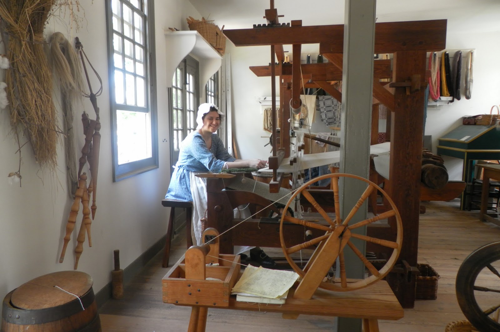
Woman weaving cloth in a traditional manner

The smaller shops included silversmiths, cobblers, weavers, basket-makers, a wig-maker, and many more. At each shop, the actor was working his or her craft while explaining the process and history behind it. Of all the shops, I found the weaver's shop to be the most interesting (though that was perhaps because I had the most knowledge about yarn and the dying process.) I would have purchased some of their hand-spun and hand-dyed yarn, but it was $25/skein!

Benedict Arnold in front of the Capitol Building

In addition to all the wonderful buildings and shopkeepers, there were also a number of historic re-enactments throughout the day. Some were more interesting than the others; however, the highlight was an afternoon production that involved the British storming the capital and placing Benedict Arnold in charge of the city. It was interesting - though Benedict Arnold proved very difficult to photograph since he was overly dramatic in his role. However, it made a good ending to a day in the 1700s.

Saturday, June 1, 2013

Monticello

Monticello reflected in the house's fish pond

This morning, I made the 4-hour drive to Charlottesville in central Virginia. A couple months ago, I had seen a picture similar to the one above, and decided that I really wanted to visit Thomas Jefferson's plantation home, Monticello. After reading a long biography of Jefferson, I finally decided to book the tickets for my brief weekend getaway.

At Monticello, there are two basic ticket types. The standard admission is about $20 and covers the first floor of the home and tours of both the garden and the slave quarters. For $40, however, you can get this - plus a behind the scenes tour of Monticello's upper floors. Since I figured this would likely be my only visit I'd ever make to Monticello, I went ahead a splurged on the more expensive tour.

The West Lawn at Monticello

My "Behind the Scenes" home tour was scheduled for 2:30, so I had plenty of time to explore before my guided tour. I spent some time in the museum, but found it a little lacking. Fortunately, I was able to join the hour-long guided tour on "Slavery at Monticello." Although this tour was fairly educational, I found it a little disappointing. The tour was little more than an educational lecture - there was nothing really to see (just the empty spaces which once contained slave quarters...you would have thought that they could have reconstructed at least one of the cabins.)

Fortunately, the slavery tour did fill most of my time, so I simply walked the grounds taking pictures while I awaited my house tour. When it came time for the house tour, I learned that the "Behind the Scenes" groups are much smaller than the normal groups (which are herded through the house at 15-minuter intervals.) My group of about 15 was first led through the ground floor (which all the tours see and is decorated as it was in Jefferson's day. Eventually, we were led to a very narrow stairwell and continued to the second and third floors.

In the recent past (like six-months ago), these upper floors were used as the museum's offices; in fact, they are currently still in the process of renovating these rooms. Only one of the rooms had actually furnishings, but it was very interesting to see the unfinished rooms (we could see what the flooring under the stoves was like and how the beds looked when not outfitted with bedding.) The highlight of the upstairs tour is the dome room atop the house (the large empty room directly below the front dome.) Overall, it was a very impressive tour (and well worth the extra $20.)

Monticello's vegetable garden

After the house tour, I continued with a tour of the flower and vegetable gardens that surrounded the house. I was actually surprised how many flowers were in bloom (I thought the summer heat would have killed them...) After the garden tour, I made a quick stop at the Jefferson's grave site and continued back to my car. It was a long (hot) day at Monticello, but I definitely enjoyed myself.

Saturday, May 18, 2013

Raven Rock State Park

Campbell Creek Trail

This morning, I traveled 30-miles (50 KM) north to Raven Rock State Park, a small park that wraps around the Cape Fear River. When I drove to the park, I intended to hike the Campbell Creek Trail (which is decent-length 5.5-miles (9 KM) hike.) My guidebook recommended this trail because it is the park's least traveled trail - and provides quiet walks through the woods. The first three-miles of the trail pasted through a forest filled with the sound of animals (birds, frogs, and a variety of small rodents shuffling through the dead leaves.)

Lanier Falls

After walking about three-miles of the Campbell Creek Loop, I came to a small side trail that descended to the Cape Fear River and a very small Lanier Fall (thankfully I had read in advance that the waterfall was only a couple feet tall, so I wasn't expecting a huge waterfall!) The river and "waterfall" provided a welcome break from the forest, though the river banks were a little crowded...

Mountain Laurel Growing along Campbell Creek

After the waterfall, I the trail continues along the river until it meets Campbell Creek. From here, the trail turned away from the river and followed the smaller creek for a couple more miles. Although the creek provided a welcome view, it definitely didn't look like water I'd want to step in! For some reason the water was nearly stagnant (and almost black in some areas); although this didn't make me want to swim, it did provide some nice reflective surfaces. It was particularly nice since there were several mountain laurel trees growing along the creek's banks (and throughout the park!)

Cliffs of Raven Rock

After finishing with the Campbell Creek Trail, I decided that it would be a shame to leave the park without seeing the shorter (and more popular) Raven Rock Trail. This 2.5-mile (4 KM) trail loops through a thicker portion of the forest (and leads to Raven Rock Cliff.) Raven Rock is a large sandstone cliff that borders the coast of the Cape Fear River; after descending several flights of stairs down the cliff, I was a little disappointed by the actual cliff.

When I returned up the cliff, I continued around the loop trail, which provided little else of interest other than a small lookout point that provided a panoramic view of the Cape Fear River and the surrounding forest. I believe the view from this lookout would be much better in fall or winter (there were far too many leaves at this point to provide a good view...) After a long morning of hiking, I finally found my way back to the parking lot and returned home for a quiet afternoon.

Sunday, May 12, 2013

Harmony Hall Plantation

Harmony Hall Plantation

As I was driving to Wilmington last month, I noticed a sign for Harmony Hall Plantation (one of the oldest homes in North Carolina.) Since the plantation is only opened 4 hours/weeks (Saturdays from 12:00 - 2:00, and Sundays from 2:00 - 4:00), I wasn't able to visit the plantation on my way back from Wilmington (fortunately, the plantation is only 25 miles (40 km) from Fayetteville....so it wasn't an impossible drive.

Now, when I hear the word "plantation", I tend to think of Gone with the Wind's Tara or other large antebellum homes. Sadly, Harmony Hall bears no resemblance to these later, more elaborate, homes. Built around 1760, the two-story home is a very simple structure with only two rooms on each floor (and a very scary-looking attic above.)

Dining Area of Harmony Hall

The first floor included a middle hall (which was quite cool thanks to the front and back doors provided a breeze through the house.) On one side, was a simple dining area, which looked very much like a 18th-century colonial room; the other room was a living area, which was obviously furnished with furniture from a much later time period.

Climbing the exterior stairs led to two unremarkable bedrooms. A smaller set of interior stairs let to a small, and very creepy attic-space (which was furnished with nothing but a bed.) The attic was probably a very good representation of a room during the time period, but I don't think you could paid me enough to sleep in that room (it was scary in the middle of the day!)

Kitchen at Harmony Hall

After the tour of the main house, I saw the outlying kitchen and several other historic buildings (which were not original to the site.) Overall, Harmony Hall was a somewhat interesting site - though I wish I could have timed it so that it had been a 20-minute stop on my way to or from Wilmington.